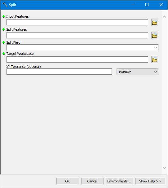
Using ArcGIS 10.8.1 Split tool, an input layer with overlaying polygons can be split into a subset of output feature classes. Split takes input features and creates a subset of output feature classes. Follow these step-by-step instructions:
1. Launch ArcGIS: Open ArcGIS Desktop on your computer
2. Create or open a map: Create a new map or open an existing one containing the input layer you want to split and the overlaying features.
3. Add input and overlay layers: If you haven’t added the input and overlay layers to your map, click on the “Add Data” button, navigate to the location of your shapefiles or feature classes, select them, and click “Add.”
4. Open the “Split” tool: Go to the “ArcToolbox” window. If it’s not visible, click on “Geoprocessing” > “ArcToolbox.” In the “ArcToolbox” window, navigate to “Analysis Tools” > “Overlay” > “Split.”

5. Set the parameters:
5.1. Input Features: Click the dropdown menu and select the input layer you want to split.
5.2. Split Features: Click the dropdown menu and select the overlaying features layer you want to use to split the input layer.
5.3. Split Field (optional): If the overlaying features layer has an attribute field you want to use to name the output feature classes, select it from the dropdown menu. If you leave it blank, the output feature classes will be named based on the FID/OID of the split features.
5.4. Output Workspace: Click the folder icon and browse to the location where you want to save the output feature classes. Choose a folder or geodatabase to store the output.
6. Run the “Split” tool: Click “OK” to run the tool. The process may take a while, depending on the size and complexity of the input and overlaying layers.
7. Add the output feature classes to the map: After the tool has finished running, go to the “Catalog” window, navigate to the folder or geodatabase where you saved the output feature classes, and drag them onto the map. Alternatively, you can click the “Add Data” button and browse the output feature classes’ locations to add them to the map.
8. Inspect the results: Once the output feature classes are added to the map, you can turn on and off different layers to inspect the results of the split operation. Verify that the input layer was split correctly based on the overlaying features.
In ArcGIS 10.8.1, you have successfully created a subset of output feature classes by splitting an input layer with overlaying features.